
Hampton Roads planners recommend 18 transportation projects in Williamsburg area
Draft list of goals through 2050 has 3 projects in Williamsburg, 7 in James City County and 6 in York County, several other regional initiatives round out the area's total
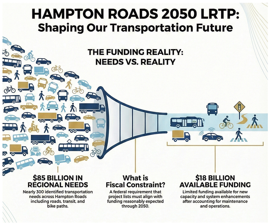
The Hampton Roads Transportation Planning Organization (HRTPO) is finalizing its 2050 Long-Range Transportation Plan (LRTP), a federally required blueprint identifying the region’s most significant transportation investments over the next 25 years. Of the $43.29 billion in revenues expected through 2050, roughly $25.2 billion is already obligated for maintenance and debt service, leaving $18.07 billion for new capacity improvements, of which $15.2 billion has been allocated to a draft list of 162 initiatives spanning roadway, active transportation, transit, and study categories across the region.
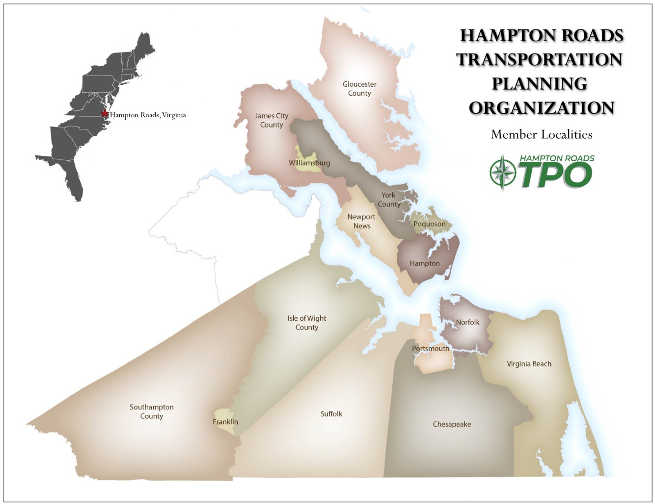
The HRTPO is a regional planning body where state and local officials from 15 member localities, including Virginia Beach, Norfolk, Chesapeake, Williamsburg, James City County, and York County, collaborate to guide transportation investment across Hampton Roads. Local jurisdictions are represented on the HRTPO board by voting members Mayor Douglas G. Pons of Williamsburg, Board of Supervisors Chair John J. McGlennon of James City County, and District 5 Supervisor Thomas G. Shepperd, Jr. of York County.
In the greater Williamsburg area, the plan includes several notable investments. Committed road improvements on Capitol Landing Rd and Ironbound Rd carry forward from the 2045 plan, joined by new shared-use paths on Lafayette St and Strawberry Plains Rd. Most significantly, the Peninsula High Capacity Rail Transit project connecting Williamsburg to Newport News earned a prioritization score of 182, reflecting strong regional support for expanded transit options on the Peninsula.
Neighboring James City County has the most extensive local project list of the three localities. Committed investments include widening Croaker Rd, extending the Longhill Rd shared-use path, and reconstructing the Pocahontas Trail corridor with pedestrian amenities. Additional candidate projects target capacity expansions on Longhill Rd (two phases), Centerville Rd, and Rt 199/Humelsine Pkwy, along with a new Centerville Rd bike lane. Rounding out the county’s list are two multi-jurisdictional projects, the Upper James River Bridge to Surry County and the Mooretown Rd Extension, which reflect James City County’s role as a critical regional connector.
York County’s plan similarly prioritizes capacity along its primary corridors. Committed widenings on US 17 and Victory Blvd carry forward from the 2045 plan, and two new fiscally constrained additions were finalized in January 2026: widening Victory Blvd (Rte 171) from Hampton Highway to the Poquoson city line at an estimated cost of $176.7 million, and Phase I of the J. Clyde Morris Blvd widening at $61 million. Candidate projects propose further expansion of US 17 in two phases and widening Denbigh Blvd from the Newport News city line to US 17. Three new shared-use paths along Victory Blvd and Yorktown Rd round out the county’s active transportation investments.
Projects were selected based on existing funding commitments, regional prioritization scores, and available revenue. Funding was also deliberately balanced across transportation modes and road classifications to ensure equitable distribution across the network. The draft plan recently closed a 30-day public comment period (deadline: March 11, 2026). Board approval is targeted for March 2026, with a regional conformity review through May and final LRTP adoption anticipated in May 2026.
Below is a full breakdown of what is planned, what has changed since the 2045 plan, and what it all means for communities in Williamsburg, James City County, and York County. The coverage includes which projects made the cut, how regional transit rose to the top of the priority list, and what major road and trail investments are planned along key corridors. It also examines how the region is building storm resilience and sea-level rise into its project selection process, and how local governments can leverage the development review process to advance transportation improvements even before full funding is in place.
Regional breakdown
Williamsburg
Williamsburg’s 2050 plan includes five projects spanning road improvements, active transportation, and regional transit. Two committed projects carry forward directly from the 2045 plan. The first is Capitol Landing Rd, a road diet project that will reduce lanes from 4 to 2 while adding a center turn lane between Bypass Rd and Merrimac Trail. The second is the Ironbound Rd widening, which will expand the road from 2 to 3 lanes and construct a new multi-use path between Richmond Rd and DePue Dr. Both were fully funded in VDOT’s Six-Year Improvement Program and transition seamlessly into the 2050 cycle.
Beyond those carry-overs, two active transportation projects round out the city’s non-transit investments. The Lafayette St Shared Use Path, running from Richmond Rd to Virginia Ave, evolved from a prior roadway widening project and earned a prioritization score of 153. The Strawberry Plains Rd Shared Use Path, connecting Ironbound Rd to Berkeley Ln and scoring 152, is the only entirely new Williamsburg project introduced in the 2050 plan. Together, these two paths reflect a growing emphasis on bicycle and pedestrian connectivity in the city’s core corridors.
The most significant addition, however, is the Peninsula High Capacity Rail Transit project, a multi-jurisdictional fixed guideway connection linking Williamsburg to Newport News. Evolved from the 2045 plan’s Peninsula Commuter Rail concept, this project earned the highest prioritization score of any Williamsburg project at 182, signaling broad regional support for expanded transit options along the Peninsula.
James City County
James City County carries the most funded local project list of the three localities, with seven projects on the Draft Fiscally Constrained Project List spanning roadway capacity, active transportation, and multi-jurisdictional infrastructure. Two committed projects carry over directly from the 2045 plan: Croaker Rd will be widened from 2 to 4 lanes between Richmond Rd and Rochambeau Rd, and the Pocahontas Trail will be reconstructed with a sidewalk, paved shoulder, pedestrian lighting, and bus pull-outs near James River Elementary School. Newly added to the committed list for the 2050 cycle is the Longhill Rd Shared Use Path, which will extend the existing path to connect to DePue Dr.
Several additional roadway projects also made the Draft Fiscally Constrained Project List. Longhill Rd widening advances in two phases, expanding from 2 to 4 lanes between Olde Towne Rd and Warhill Trail, and then continuing from Warhill Trail to Centerville Rd. Both phases saw improved prioritization scores compared to the 2045 plan, reflecting increased demand along that corridor. The Centerville Rd widening from 2 to 4 lanes between Richmond Rd and Longhill Rd also made the fiscally constrained list. Two additional projects were evaluated but did not make the funded list: the Rt 199/Humelsine Pkwy widening from 4 to 6 lanes between Route 5 and Colonial Pkwy (score: 126) and the Centerville Rd Bike Lane from John Tyler Hwy to Monticello Ave (score: 102), both of which remain unfunded candidates in the draft 2050 plan.
Rounding out James City County’s list are two multi-jurisdictional projects with regional significance. The Upper James River Bridge proposes a new 4-lane crossing connecting the Lower Peninsula to Surry County on the Southside, scoring 127. The Mooretown Rd Extension will create a new 4-lane connection between Lightfoot Rd and Croaker Rd, scoring 99. Both projects underscore the county’s role as a critical link in the broader regional transportation network.
York County
York County’s 2050 plan focuses primarily on expanding capacity along its major corridors while introducing new active transportation options. As a foundation, two committed widenings carry forward from the 2045 plan: US 17 will be expanded from 4 to 6 lanes between Wolf Trap Rd and Route 173, and Victory Blvd will be widened from 5 to 6 lanes between US 17 and Hampton Hwy.
In addition to those carry-overs, two projects were added to the fiscally constrained list following a January 2026 committee meeting. Victory Blvd (Rte 171) will be widened from 2 to 4 lanes between Hampton Hwy and the Poquoson city line, at an estimated cost of $176.7 million. To help fund that addition, the J. Clyde Morris Blvd widening was restructured from a single project into three phases, with only Phase I retained on the funded list at an estimated cost of $61 million. Phases II and III will remain as unfunded candidates in the regional vision plan.
Looking further out, several candidate projects address remaining gaps along the county’s key corridors. US 17 widening is proposed in two phases, from the Coleman Bridge to Fort Eustis Blvd (score: 140) and from Fort Eustis Blvd to Denbigh Blvd (score: 123). Denbigh Blvd is also proposed for widening from 2 to 4 lanes between the Newport News city line and US 17, scoring 86. Complementing these roadway investments, three new shared-use paths are planned along Victory Blvd and Yorktown Rd, expanding the county’s active transportation network and connecting key destinations across the corridor.
Evolving considerations
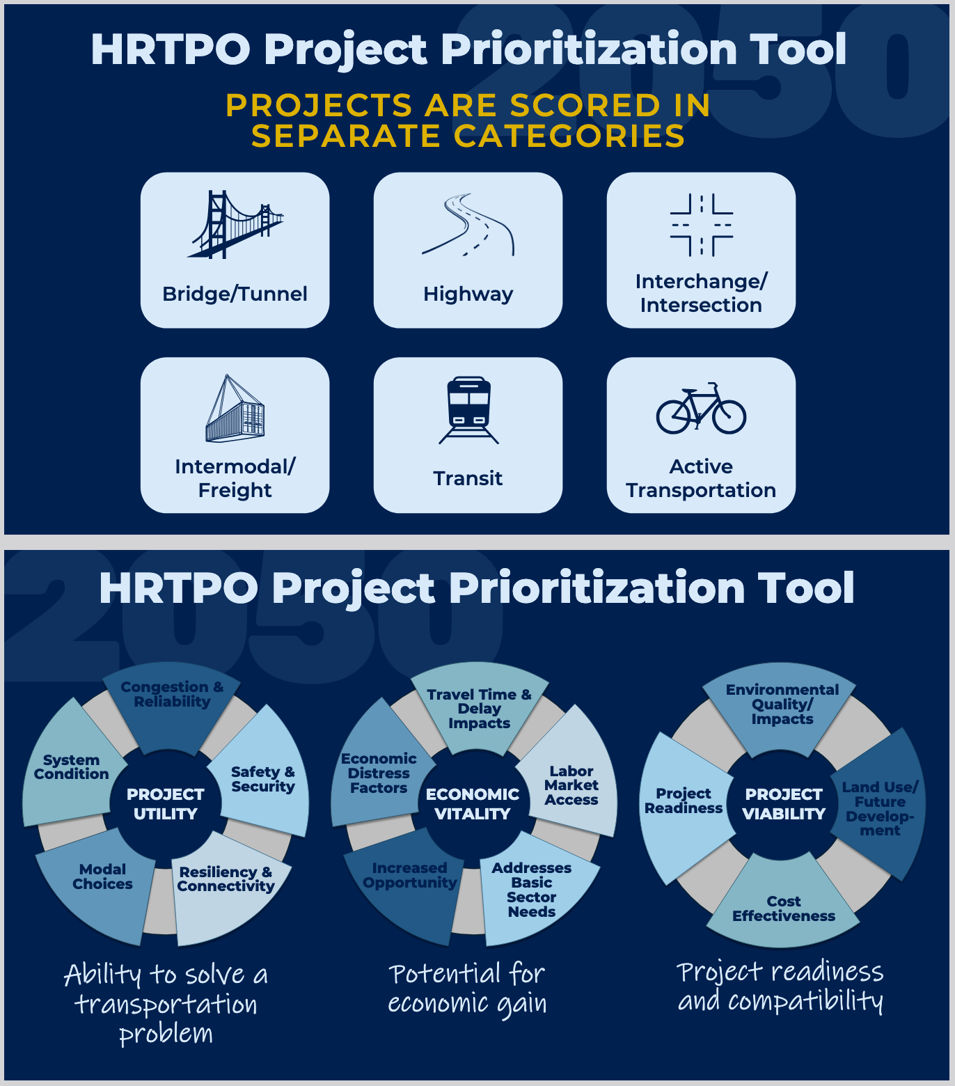
The HRTPO continuously refines how projects are prioritized and implemented. In July 2025, the board approved resiliency enhancements to its Project Prioritization Tool, using the US DOT Volpe RDR Tool Suite to evaluate projects across thousands of future hazard scenarios, rewarding those that minimize trip loss, preserve access to critical facilities, and serve as the everyday network backbone. Separately, a March 2026 guide outlined how local governments can use the development review process to advance transportation projects before full public funding is in place, leveraging zoning incentives, comprehensive plan integration, and early developer negotiations to reserve right-of-way and construct paths and road improvements.
Advancing road & trail/path projects
In March 2026, the HRTPO produced a guide for local governments on using the development review process to advance planned transportation projects, prepared at the request of Gloucester County. Because Virginia law limits mandatory right-of-way dedications, localities must negotiate strategically with developers through zoning ordinances, comprehensive plans, and voluntary proffers.
For trails and paths specifically, the guide outlines several effective strategies. Localities can keep future path alignments clear by requiring developers to show planned routes on their site plans, and can secure easements in floodplains where land is rarely viable for development. By formally embedding trails into a Comprehensive Plan or Regional Bikeway Map, localities set the expectation that developers will either build the path across their site or reserve space and contribute funds for future construction. Zoning incentives can also play a role, such as offering parking reductions to developers who provide bicycle and pedestrian accommodations.
To put these strategies into practice, the report recommends that localities establish Pre-design Site Development Review Committees to engage developers before formal submissions, giving planners an early opportunity to negotiate path alignments and dedications before site designs are finalized.
Resiliency enhancements to project prioritization
In July 2025, the HRTPO Board approved significant updates to its Project Prioritization Tool to better account for the region’s vulnerability to climate disruptions, including 3 to 4.5 feet of sea-level rise combined with major storm surges. To evaluate candidate projects against thousands of potential future hazard scenarios, the HRTPO integrated the US DOT Volpe Resilience and Disaster Recovery (RDR) Tool Suite, which calculates a project’s return on investment and potential “regret” cost if left unbuilt before a disaster strikes. These enhancements are now embedded across all three prioritization categories. Under Project Utility, projects are rewarded for retaining 90% or more of trips during disruptions and preserving access to hospitals, shelters, and emergency services. Under Economic Vitality, a new submeasure evaluates how well a project protects mobility for transportation-vulnerable communities during hazard events. Under Project Viability, the RDR tool calculates financial effectiveness based on projected savings in delay and repair costs across multiple scenarios.
Complementing those resiliency measures, the updates also introduced a new Infrastructure Criticality metric designed to identify the backbone of the transportation network under everyday conditions, not just during hazard events. This metric scores roadways based on objective factors including future traffic volumes, travel time reliability, designated evacuation routes, military access, and port and freight impacts. Together, the resiliency enhancements and criticality metric give planners a more complete picture of a project’s long-term value, ensuring that the projects selected for the 2050 LRTP are built to serve the region reliably for decades to come.
The writer used AI tools and these sources:
Promoting Planned Road & Path Projects via the Development Review Process
DRAFT 2050 LRTP Fiscally Constrained Project List (Presentation)
Other ways to support the Williamsburg Independent:
Buy me a coffee: ko-fi.com/williamsburgindependent
Tip on PayPal: paypal.com/ncp/payment/2L8DQJ62CWGRS
Go shopping: etsy.com/shop/dogstreetpress
Read a book: bookshop.org/shop/independentbookshop
Facebook: facebook.com/williamsburgindependent
Twitter: x.com/WburgIndie